|
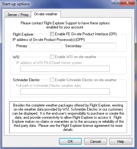
Enable FE On-site product Interface (OPI)
|
Indicates whether you would like to enable the on-site weather options.
Flight Explorer uses the OPI format to display raster and vector based dynamic overlays in the Professional version. at a customer's facility. The OPI weather product includes hot spots. When users right-click the hot spots, they are linked to other weather products on a new layer or other map.
|
|
IP address of On-site Product Processor(s) (OPP)
|
Primary and Secondary - Indicates the address that Flight Explorer connects to.
|
|
Weather Vendor Purchased Separately
|
Flight Explorer supports on-site weather data supplied by other weather vendors that you can purchase separatelythe Weather Services International PilotBrief Vector system. You must have a WSI Site License so that Flight Explorer may use the Vector weather at your site. (Please contact WSI to determine whether you have a Site License for your PilotBrief Vector system, and to authorize this use.)
|
|
Enable the weather vendor you purchased
|
Enables the weather vendor that you purchased.
Indicates whether you would like to enable the WSI on-site weather products.
Supported WSI On-site Weather Data Files
- NEXRAD 2km composite
- NEXRAD 2km composite (WxType)
- NEXRAD radar summary
- NEXRAD 2km San Juan
- NEXRAD 2km Alaska
- NEXRAD 2km Hawaii
- US IR Satellite
- Airmets
- Sigmets
- Convective Sigmets
- Watches/Warnings
|
|
IP address of the weather vendor you purchased
|
The IP address of the weather vendor you purchased.
To display weather from your WSI PilotBrief Vector system, enter the Vector IP address in the, and press OK. When you start Flight Explorer after having set the on-site WSI options, Flight Explorer will detect which of the above products are available on your Vector System and will automatically add options to the weather menu for these products. All on-site WSI weather products begin with "WSI-" to differentiate them from the Flight Explorer supplied weather products. All Flight Explorer view settings apply to on-site weather as well as the Flight Explorer delivered weather products
|
|
Schneider Electric
|
For those customers who have Schneider Electric on-site weather systems, Schneider Electric the data files are usually stored on a server in sub-directories from a common root directory. You will need to provide the connectivity to the server where the files are stored using Microsoft, Netware or other networking software. Once you have connectivity, you should map a drive to the volume containing the Schneider Electric data or use the full \\servername\sharename path.
|
|
Enable Schneider Electric on-site weather
|
Indicates whether you would like to enable the Schneider electric weather products.
See below for supported Schneider Electric on-site weather files.
Supported Schneider Electric On-site Weather Data Files
- MNG: Master NEXRAD Grid (1km, 5 minute national NEXRAD with rain/mix/snow indicator)
- MRS: Master Remapped Satellite (11 worldwide regions & 1 worldwide summary, NAT, N1, N2, N3, N4, N5, S1, S2, S3, S4, S5, WW)
- If you are not already receiving these files on your Schneider Electric feed you will need to contact Schneider Electric to have them turned on.
- When you start Flight Explorer after having set the on-site Schneider Electric options, Flight Explorer will detect which of the above products are available in your Schneider Electric directory (and sub-directories) and will automatically add options to the weather menu for these products. All on-site Schneider Electric weather products begin with "MET-" to differentiate them from the Flight Explorer supplied weather products. All Flight Explorer View settings apply to on-site weather as well as the Flight Explorer delivered weather products.
|
|
Full path to Schneider Electric weather data
|
In the Full path to Schneider Electric weather data files entry in Flight Explorer you should indicate the full path (drive mapping or server\share name) to the root Schneider directory (i.e. f:\Schneider or \\server name\share name).
|
![]() Click to see the Start-Up Options window
Click to see the Start-Up Options window
