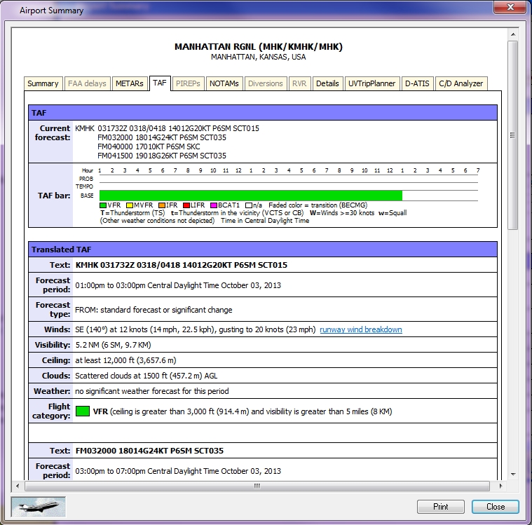
TAF Tab
Terminal Area Forecasts or TAF's shows forecasted weather conditions for each terminal at an airport. See Surface Forecast for more information.
To view the TAF tab
Right-click on any airport and select Airport Summary from the Context menu.
The TAF tab ![]() appears
appears
This information includes:
|
Item |
Description |
|---|---|
|
Current Forecast |
Describes the forecast for this airport. |
|
TAF bar |
A color coded visual aid. |
|
Text |
Can include the airport ID, time, conditions, ceiling, visibility, etc. |
|
Forecast Period |
The time and date this information was made available. |
|
Forecast Type |
Describes changes in the forecast. |
|
Winds |
Shown in direction, degrees, knots and miles. |
|
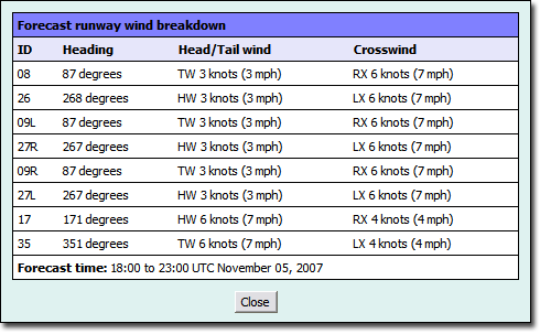
Runway Wind Breakdown Link |
Opens a Forecast Runway Winds Breakdown table that shows the runway ID, wind heading, head/tailwind speed, and crosswind speed. TAF Runway Wind Breakdown Table |
|
Visibility |
Describes the distance that can be seen in nautical miles and statute miles. |
|
Ceiling |
Range of ceiling height. |
|
Clouds |
The type of clouds at different heights. |
|
Weather |
Describes the type of weather for the period. |
|
Flight Category |
As determined by ceiling and visibility and given a color value (see below). |
Weather conditions are color coded to show visibility range in the TAF bar, as well as, types of conditions such as, thunder (T) and wind (W) (indicated in the TEMPO row).
|
Color |
Description |
Ceiling |
Visibility |
|---|---|---|---|
|
Green |
VFR |
>3k ft |
> 5 mi. |
|
Yellow |
MVFR |
1k - 3k |
3 - 5 mi. |
|
Orange |
IFR |
500 - < 1k ft |
1 - < 3 mi. |
|
Red |
LIFR |
200 - < 500 ft |
1/2 to < 1 mi. |
|
Pink |
BCAT1 |
< 200 ft |
< 1/2 mi. |
|
White |
|
Not available |
|
|
Faded Color |
BECMG |
Transition to another level (becoming another color) |
|

