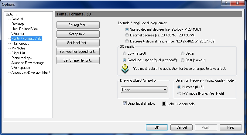
Options - Fonts / Formats / 3D
Select Options on the Tools menu to open Fonts / Formats. The default for all Flight Explorer application fonts is Tahoma, Regular, 7pt. A custom smaller or half size can be inserted into the font size window manually.
![]() Click to see the Fonts/Formats/3D window
Click to see the Fonts/Formats/3D window
|
Item |
Description |
|---|---|
|
Set Tag Font |
Set the font, font style and font size for aircraft tags. Tags can be enabled in User Defined Views - Planes. |
|
Set Tip Font |
Set the font, font style and font size for hot tips. Tips can be viewed by holding the mouse over an aircraft in the map window. |
|
Set Label Font |
Set the font, font style and font size for all Flight Explorer overlay object labels. |
|
Set Weather Legend Font |
Set the font, font style and font size for the on-screen weather legend . |
|
Set Shape File Font |
Set the font, font style and font size for the on-screen shapes. |
|
Latitude / Longitude Display Format |
Set the display format for latitude and longitude to signed decimal degrees (123.4567,23.4567, etc.), decimal degrees (123.4567W, 23.4567N, etc.) or degrees and decimal minutes (W123 27.402, N23 27.402, etc.) The Lat/Long display format affects only the display of Latitudinal and Longitudinal data. Any input fields for Latitude and Longitude data can accept any format of Lat/Long coordinates, regardless of the setting used for display. |
|
3D Quality |
Set the quality for spherical projection (3D mode) based on a trade off between performance and quality. The available Quality options are "Low (fastest)", "Good (best speed/quality tradeoff)", "Better", and "Best (slowest)". The default setting is "Good". The application must be restarted before changes to this setting will take effect. |
|
Drawing Object Snap -To |
Allows for drawing objects to snap-to a particular point. You can select from a list of values how you would like drawing objects to snap. Select from:
|
|
Diversion Recovery Priority display mode |
Set the diversion recovery priority display mode to Numeric (0-15) or FAA mode (None, Yes, High) |
|
Label Shadow |
Select the draw label shadow check box, if you want to draw a label shadow and click the box to select the label shadow color. |
