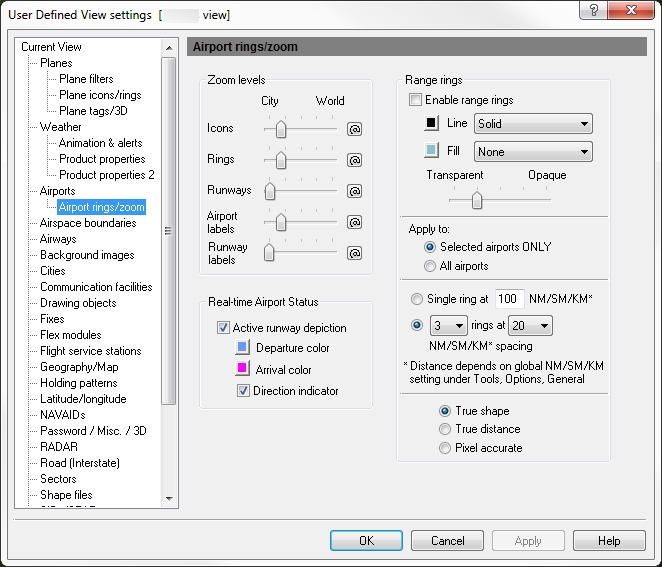
Airport Rings / Zoom
![]() Click to see the User Defined View Airport Rings / Zoom
window
Click to see the User Defined View Airport Rings / Zoom
window
|
Item |
Description |
|---|---|
|
Zoom Levels |
Use the slider to choose the level that buttons, labels, range rings, runways, and runway labels are visible on screen. Click the @ button to select the current zoom level. The corresponding item will be visible from the selected zoom level to the lowest zoom level (city). |
|
Real-time Airport Status |
An area where you can select how you would like the runways to appear on the map. After you make your selections here, click the Airport overlay on the main ribbon to turn on the runways.
|
|
Range Rings |
Distance rings around selected airports are configured using this option. For each airport in the selection list, range rings can be enabled individually by clicking on the Ring field. |
|
Enable Range Rings |
Turns all range rings on or off. |
|
Line |
Choose whether there should be a solid visible line with color or no line. Click the color box next to the check box if you want to change the color of the airport that appears on the map. |
|
Fill |
Choose whether the ring should be filled in with a color or have none. Click the color box next to the check box if you want to change the color of the airport that appears on the map. |
|
Transparency slider (color density) |
Decide if the color selected in Line and Fill above should be Transparent (see through) or Opaque (solid) by moving the slider left or right. |
|
Apply To |
Rings can be applied to:
|
|
Single Ring Option |
Select to draw a single ring around each airport at a user defined distance from 0 to 5,000 nautical miles. |
|
Number of Rings & Ring Spacing |
Number of concentric rings (1 through 5) to draw around each airport at a selected distance. Spacing between rings in nautical miles, statute miles, or kilometers. Ranging from 5, 10, 20, 30, 40, or 50. |
|
True Shape and True Distance |
With the True shape option, the shape is drawn accurately but radial distance may not be constant. With the True distance option, the radial distance is constant but shape may not be drawn accurately (depending on map projection). |
14.3 release: added the Real-time Airport status area.
