UDV - NAVAIDs
The NAVAID (navigational aid) overlay is used to provide positional data of an aircraft in flight and are established by and continually updated with, the latest data from the FAA. For example an aircraft flies from NAVAID to NAVAID, Fix to NAVAID, Fix to Fix, etc. NAVAIDs are represented by an icon and the id number.
To Use a NAVAID View
Click the View Settings icon on the Main toolbar, User Defined View Settings (CTRL + V) on the View menu, and then click NAVAIDs, or the down arrow on the Navigational Aid (NAVAID) Overlay icon on the Overlay toolbar, then NAVAID View Settings.
![]() Click to see the User Defined View NAVAIDs window
Click to see the User Defined View NAVAIDs window
To Activate a NAVAID View
The overlay must be enabled first by clicking the Show NAVAID Overlay check box in User Defined View Settings -> NAVAIDs or by clicking the down arrow on the Navigational Aid (NAVAID) Overlay icon on the Overlay Toolbar, then selecting NAVAID View Settings.
To turn on the NAVAIDs overlay, click the Navigational Aid (NAVAID) Overlay icon on the Overlay toolbar, or select NAVAIDs (ALT+N) on the Overlays menu.
|
Item |
Description |
|---|---|
|
Detail Options |
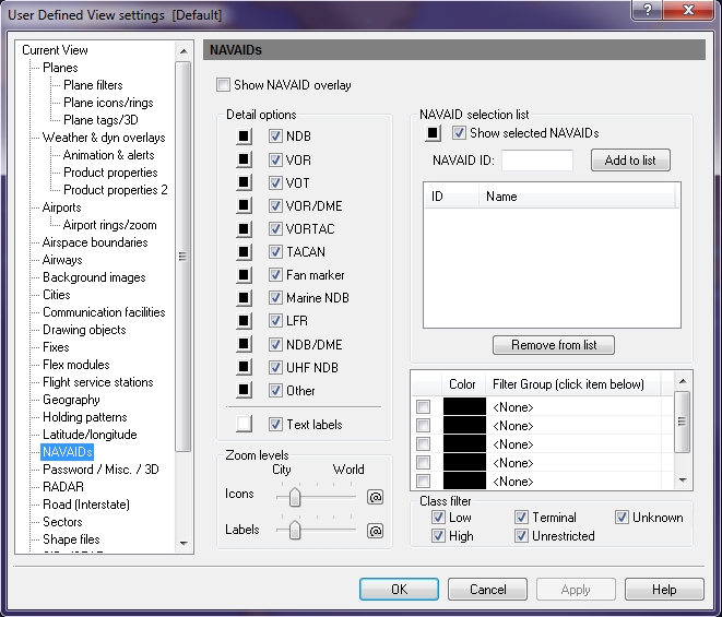
More than one NAVAID can be selected by clicking the corresponding checkbox. Select colors for each by clicking the appropriate color button. NAVAID text labels can be turned on or off, and a color can be selected. To quickly enable text labels, click the arrow on the NAVAIDs icon on the Overlay toolbar and then select Show Text Labels. |
|
Zoom Levels |
Use the slider to choose the level that icons and labels are visible on-screen. Click the @ button to select the current zoom level. The corresponding item will be visible from the selected zoom level to the lowest zoom level (city). |
|
NAVAID Selection List |
In addition to the NAVAIDs enabled in Detail Options, individual NAVAIDs can be turned on by adding them to the selection list. To enable the display of NAVAIDs listed in the selection list, click the check box labeled Show Selected NAVAIDs. To select the color in which these NAVAIDs will be shown, click open the color palette, click the color you want and then click Apply. More than one location can have the same NAVAID ID using different navigational aid types. These duplicate instances will all be listed when available. To include specific groups of NAVAIDs, select from the Include Group list (see Tools, Features, & Settings -> Options -> Filter Groups for more information). For example: LAL is the id for Lakeland Florida in NDB (Nondirectional Radio Homing Beacon) and is also the id for Tacamiche, Honduras in VORTAC (VHF omnidirectional range with TACAN - Tactical Aircraft Control & Navigation). |
|
NAVAID Filter Group List |
Groups of NAVAIDs can be turned on by adding them to the Filter Group selection list (see Tools, Features, & Settings -> Options -> Filter Groups for more information). |
|
Class Filter |
Check box area indicating which class you would like to use with the available options. All of the check boxes are checked by default. Low, High, Terminal, and Unrestricted apply only to VOR, VOR/DME, VORTAC, and Other.
|
