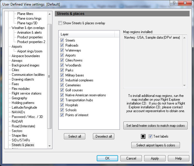
User Defined View Streets & Places
You can use the Streets and Places window to manage the streets and places that appear on the map.
Streets and Places are landmarks used on maps. Select layers of geographic landmarks by opening the Streets & Places window.
To open Streets & Places window
- Click the View Settings icon on the Main toolbar, User Defined View Settings (CTRL + V) on the View menu.
- Click Streets & Places, or the down arrow on the Streets & Places Overlay icon on the Overlay toolbar, then Streets & Places View Settings.
![]() Click to see the User Defined View Streets & Places window
Click to see the User Defined View Streets & Places window
|
Item |
Description |
|---|---|
|
Layer |
Each layer represents a different landmark. |
|
|
|
Map Regions Installed |
Lists currently installed and available map regions. Run the map installer (click NAVTEQ Maps) on the Flight Explorer installation CD to install additional map regions. Scroll to see 13 region names at a time. |
|
Select All |
Click to select all the layers in the list. |
|
Deselect All |
Click to un-select all the layers in the list. After un-selecting all the layers you can select only the layers you want. |
|
Set Land / Water Colors to Match Map Colors |
Click to automatically change geography color settings found in Geography, to those used for the Streets & Places maps. |
|
Text labels |
Click to view all streets and places labels including new airport objects at a predefined internal zoom level. |
|
Select airport layers & colors |
Click to launch the Airport Map Colors window which allows you to toggle the airport layers and/or set their colors. |
